The Freedom Rolling Blog
The Space Coast of Florida
"Space, the final frontier." These are the journeys of Freedom Rolling. Its continuing mission to explore odd tourist destinations. To seek out new states and new attractions. To boldly go where many have gone before.
OK, so Kirk and Picard we are not, but one favorite destination has to be the Space Coast of Florida. Situated between Daytona and Melbourne, the Space Coast was originally chosen in the 1950's being one of the more undeveloped eastern coasts of Florida, but now houses one of the most famous Space Force launch ranges, and attracts many enthusiasts from around the world. Spend a little time in the cities of Titusville and Cape Canaveral, where helpful locals can clue you in on the best sights and deals. Maybe catch a wave or two on the Atlantic Ocean. If fishing tickles your fancy, plenty of piers adorn this coast. If the RV or tent life is for you, then consider one of our well-enjoyed places to stay, Jetty Park in Cape Canaveral. This Florida State Park has its own beach and fishing pier, along with great views of the launch range.
If you came looking upward, then the Kennedy Space Center is the place for you to visit. The Visitor Center boasts a substantial "rocket garden" consisting of the many rockets of yesteryear, along with several exhibits and memorials, such as the Atlantis shuttle and a tribute to the fallen astronauts and potential astronauts in the line of duty. Take their bus tour into the Space Force Station, and you can see an actual Saturn V rocket, once ready to serve an emergency Skylab mission, and is now on display for visitors. Consider spending at least a couple days at Kennedy. With the pricing during our stay before the RV, we were able to get an annual subscription for the price of two entries, with all the associated perks.
If you can time your visit right, combined with a little luck, maybe you can be at the Space Coast on a launch day. Sure, you may have seen some of these from the comfort of your home, but nothing beats witnessing a launch live in person. The Kennedy Space Center offers ticket packages to view near the range, but perhaps you don't want to spend the extra money or be around so many visitors. Head back across the Indian River to Titusville, and there are several parks on the shore to give great viewing opportunities. NASA's website gives the location of several parks with free or limited fee viewing. Rotary Riverfront Park places you directly in front of Pad 39A, famously used during the Apollo days, and now serves as a base for SpaceX's high profile missions. Bring some binoculars or a telescope to see the propellant fills, ignition, and other activities across the river. Wireless usage will be jammed so you may not be able to livestream or hear a slightly delayed cast, but shout-outs to Space Scout for guiding visitors at Rotary Riverfront Park as to what's happening.
If you're going to follow your internal compass, don't burn out your fuse up there alone. Head out to the Space Coast and really explore humanity's journey to the stars.
WRITTEN Sep 16, 2021 at 06:23 PM
TAGS: trip 7, florida, before the rv
SHARE: Facebook Twitter Email
The Forgotten Coast of Florida
Florida is one of the most popular tourist destinations for millions worldwide. Many flock to the heat of Miami, the theme parks of Orlando, or the gulf beaches of Tampa. There's one area of the state not to miss.
Franklin County, Florida is nicknamed the "Forgotten Coast". The Forgotten Coast is situated south-southwest of Tallahassee and southeast of Panama City, along the northern shore of the Gulf of Mexico. Compared to many of the other shores of Florida, this area doesn't have the hustle and bustle that comes with the more tourist-laden parts of the state. Drive along its main highway, US Route 98, and between the small cities of Carrabelle, Eastpoint, and Apalachicola, you'll see miles of undeveloped beaches, with fishing piers here and there built by the residents along the road.
While at the Forgotten Coast, head over to St. George Island. When you get to Eastpoint, take the long causeway over the Apalachicola Bay to get there. Along the trip, you'll see a fishing pier on either side, which were converted from an older iteration of the bridge connecting the island and the mainland via several man-made islands still in existence. To the east lies St. George Island State Park, which offers RV camping and day use to visitors. To the west and central parts of the island are a multitude of houses and condominiums, along with a free public access to a pristine beach along the gulf. Although the houses are built on stilts to guard against hurricanes and flooding, no high-rises exist, giving that small-city feel.
The Forgotten Coast is also partial home to two protected forest areas: Tate's Hell State Forest, and the Apalachicola National Forest. Both are protected wetland and woodland areas along the panhandle with plenty of wildlife and vegetation. Tate's Hell has an interesting legend to its name, when an 1800's local named Cebe Tate ventured into the forest, and became lost for several days. When he returned to a part of Carrabelle, his last words were believed to be: "My name is Cebe Tate, and I just came from Hell."
So the next time your internal compass leads you to the beaches of Florida, don't feel like you have to brave the tourist destinations. Head to the Forgotten Coast, and you may find a much more pleasant experience.
WRITTEN Sep 11, 2021 at 11:21 AM
TAGS: trip 7, florida
SHARE: Facebook Twitter Email
Park Review: Campground at Barnes Crossing
Trip number seven brought a new experience for us the form of a paid dock, where we decided to stay at a campground. However, unlike the splitting of trips 4 and 5 because the stay was for a bit longer, this one is being treated as a dock. Although it is less expensive to dock at RV/Truck stops, sometimes you need to replenish the "essentials", dump the "extras", and live in a little more comfort. For us, this one night stay was at the Campground at Barnes Crossing, located outside the city of Tupelo, Mississippi. Tupelo is famously known for being the birthplace of the widely impersonated late singer Elvis Presley. This was originally supposed be a longer stay, but due to circumstances described in another blog post during this trip, it was cut to a dock. Still, like any place where we are paying customers, it will receive a proper review.
Grounds: This park is conveniently located off US Route 45 and the Natchez Trace Parkway, near the newly designated Interstate 22, otherwise known as US Highway 78. Although in a rural setting, the campground is near the Barnes Crossing commercial strip, allowing visitors to resupply as well as receive restaurant delivery services. Found off a minor state highway, this place is very well marked, however drivers should be very aware of narrow shoulders with steep drop-offs, as well as hill grades that may require lower gears during descent. Several "For Sale" signs were found along the campground road; it is unknown whether the park management will soon be changing hands, or if extra undeveloped land is being offered for additional usage.
Sites: Fifty-four RV sites adorn the campground, all with full hook-ups and an assortment of back-in and pull-through sites. Be warned, when reserving a site here, that credit/debit cards are not accepted; you will need to pay by cash or check. The sites were gravel with a small concrete pad to mount a trailer or fifth wheel front. Some pull-through sites are doubled up along a line, which could create an awkward "back out" situation, although we were placed at the front of one of these strips. A well defined indentation made lining up the trailer for hookups very easy. Water pressure was very high even with a regulator, and the sewer cap was hinged, causing some issues in securing the hose. Most, if not all, of the sites are on a hill, which even with leveling blocks, may create a "tilted" experience, as well as make traversing the park difficult.
Staff: Staff interaction was fairly minimal. Although some staff had an uncomfortable physical presentation, they were otherwise generally helpful at check-in. It is unknown whether there are workampers, if all workers are salaried, or is otherwise family operated. The staff seemed to maintain the park fairly well for what it had.
Amenities: The campground offers limited amenities, although visitors have the town nearby for entertainment. A couple pet areas are scattered around the park. The sites are in a loop that many campers enjoy walking either by themselves, or with their pets. A bath house with shower exists, but is limited to nightly guests; monthly campers are prohibited from this facility. Laundry also is available, along with a horse corral.
Atmosphere: This park seemed a bit more friendly than others, with a number of happily greeting guests. If you have children, they'll need to be entertained as a family unit. Although the stay wasn't long enough to truly grasp the harmony that may or may not exist at a campground, even just the one night makes the camper feel at home.
Overall, the Campground at Barnes Crossing receives a 7 rating out of a possible 10. In addition to some of what was previously mentioned, the park had fairly low value in terms of the price paid to stay and what was offered. In addition to the lower rating, the price point is also reason to select a different place to stay if you visit northern Mississippi, especially if for a short-term stay.
WRITTEN Sep 08, 2021 at 06:52 PM
TAGS: trip 7, mississippi, park review
SHARE: Facebook Twitter Email
Park Review: Landing Point
For trip number six, on the way to the south, another stop was had. Landing Point RV Park is an approximately 80 site ground on the outskirts of the city of Cape Girardeau, Missouri. Our stay at this full-year park was for one full week.
Grounds: This park is located a couple miles off Interstate 55 and its corresponding Business Loop through the city. It can be accessed by a rural minor state highway from the north, but access from the south requires you to take a busy thoroughfare. The signage for this place, although very unique in an old trailer, is placed parallel to the access road, resulting in the park being missed more than once. The park is located near a residential area of Cape Girardeau, along with a storage unit, restaurant, and golf course. The city, with big box and national chain convenience, is merely a short drive away.
Sites: Landing Point has approximately eighty living sites and several storage pads, all for RVs and travel trailers, mostly back-in but a few pull-through. Each site has a level concrete pad and concrete patio on which your decorations are minimally expected to be. Appropriate shade from shared trees exist. All sites have full hook-ups, including basic cable TV. Be sure you have a water pressure regulator, as the water comes from an open-close pump instead of a variable faucet. In addition, we noticed a constant smell like a non-airtight black tank not observed in any other stay. A small fire pit exists off the patio. Each site is very well marked, with a map although not up to date, easy to understand. Plenty of room is available for a tow vehicle to enjoy what Cape Girardeau has to offer.
Staff: The park's staff leaves plenty of room for improvement. Although we ensured a worker (assumed to be the owner) was at the office for an appointed check-in time, this was the extent of our good fortunes. Office staff at other times visited was either discourteous or non-existent, choosing not to man the office during some of the listed hours. Grounds staff almost immediately saw the need to bark at us about regulations, an overbearing list the park chooses to deflect on a corporation to suit their controlling desires, while ignoring an unattended dog tied outside a site that never seemed to move. Meanwhile, the aforementioned staff was seen doing "busy work", mowing lawns twice in a day instead of addressing noticed amenity deficiencies. On one occasion, the owners decided to have the entire park's water shut off because of a purported heater tank issue at their regulation-breaking not-so-portable site, and refused to notify anyone at the park. The next day, they chose to shut it off again, although notifying guests by voice mail, during when campers are trying to sanitize their grey/black tanks and fill potable before check-out, instead of scheduling for the time between check-out and first check-ins when most continuous guests are out for the day.
Amenities: The grounds offer limited amenities, although most visitors will more than likely want to experience the nearby city. The sites are on an approximately half-mile paved walking loop. A small dog park exists, although moved from where the map shows. This dog park was adorned with waste that some owners refuse to clean, and untouched by maintenance staff for what seemed like weeks in some cases. Children may enjoy a small playground. Bath houses had a very odd layout, one of which contained two shower stalls and one toilet, another of which was a powder room with no shower stall, along with the "Managment" [sic] placing an over-abundance of signage about their regulations and wanting to evict people. A community fire pit also exists, although doesn't seem to ever be in use, as what seemed like weeks of tree trimmings were piled high on the area, and never a fire seen on any day of our stay. A laundromat exists, although a bit on the pricey side, was able to suit our needs.
Atmosphere: This park seems more like a place where long-term guests just stay while doing other things. Hardly any interaction was seen during nightly walks around the grounds. Not much excitement was seen about the park, so if anyone was there, we didn't see them. Once in a while, a friendly neighbor would offer greetings. Hot and sticky weather may have contributed to these feelings, along with an abundance of rain when we arrived, but even in fair weather, activities and fun times would be noticed. Even when talking with locals around the city, no excitement is drummed about this park.
Landing Point RV Park receives a 4 rating out of a possible 10. Although the price point was on a more moderate level, it doesn't make up for the lackluster experience had. Even over-hearing a comment from another camper about getting what we pay for, we've found better experiences at lower prices. Needless to say, unless a change in management is had, we will not be returning to this park. If we ever visit the area again, there is one other RV park within the city area to try.
WRITTEN Sep 05, 2021 at 07:09 PM
TAGS: trip 6, missouri, park review
SHARE: Facebook Twitter Email
Trip 7: First Workamping Encounter
Finally, we have arrived at our destination. However, unlike the other trips, this one's for a longer term.
Some have asked how we deal with finances while on the road. Workamping, or working while camping, is one of the ways to do this. In many cases, the compensation for working at the park is a complimentary site for the length of the job, anywhere from a couple months to a year. Some may say that we aren't actually getting anything, but that's not entirely true. One of the easiest ways to save money is to not spend it. Not only are we not spending money on campground fees, but we're also not burning fuel carrying the heavy load of our home from place to place. This advice isn't limited to full-time RVers, though. If you have thoughts about saving money, decide you're not going to spend some in a month and sock it away, even if it's what seems like a small amount. After a while, it adds up.
There still has to be some sort of income despite workamping, as there are food, fuel, health, insurance, and other miscellaneous costs. How much you spend is truly up to you. Some have pensions or investments to be able to use. Others may be lucky enough to be able to get a salary as part of workamping. Some may have their own side businesses. A part-time job outside the park is also an option. However, be very careful about earning salaries when you travel. A number of states will charge you an income tax for earning money while in their state, even if you are domiciled in a state that doesn't have an income tax.
We look forward to this workamping opportunity and improving the experience of our fellow campers. This location is where our internal compass led us to be, and we hope to enjoy it for the entire time we are here.
WRITTEN Sep 01, 2021 at 12:00 PM
TAGS: rv living, trip 7
SHARE: Facebook Twitter Email
Trip 7: Detour in the Forecast
Once again, it's time to travel! The RV lifestyle makes us migratory, so it's time to head south. However, plans may not always be as they seem.
When getting ready to travel, it was previously mentioned that you want to give at least a little bit of extra time when getting to your destination. Along with this, it's necessary to have some flexibility in your route, and not just for construction, either. As we embark on this trip, all of a sudden we receive word about some inclement weather. Ida tell you all about it, but it's all over the news. Bad puns aside, this is where you want your co-pilot to be giving you updates about road and weather conditions around you and your route. In today's day and age, cellular data makes this easy and is what we use, but for those not able, there's always talk radio on the half-hours. As we track the storm, given our destination, instead of heading directly to our end location, we'll take a little trip east before heading south. Sure, it might mean a little more in gas costs, but compared to what it could be, the preventive measure is worth it.
When you live in the RV full-time, mobility is your greatest advantage. With enough advance notice, if work obligations permit, pack everything up and get out of dodge if needed. When looking at routes to get to and from your destination, never limit yourself to the interstate highways. In fact, you may not be able to reach some of the higher speed limits in the west, as clogged as they may be, so taking the state and US highways may be your best option. Remember that everything you have is with you, and it isn't that stable if you choose to abandon it, when compared to a house. But an "evac" doesn't mean you can't tow. Stick to the less-traveled byways while everyone else jams up the interstate, leave a little room for merging and swerving traffic to keep it all moving, and you and your home should be just fine.
So definitely follow your internal compass, but don't let it slam you into bad weather. Consider a byway detour. Who knows? Maybe you'll encounter something you'll like but never thought of visiting.
WRITTEN Aug 29, 2021 at 07:11 PM
TAGS: trip 7, travel, rv living
SHARE: Facebook Twitter Email
Southeastern Missouri and the Mississippi River
From one river to the next, we head south down the Lewis and Clark Trail to Missouri. After spending plenty of time at one of the country's great river, we head a little east to, arguably, its greatest river.
The Mississippi River runs north and south down the center of the United States, serving as a border and/or major water arterial for a total of ten different states. The Mississippi has always had plenty of history, first serving as the western border for the original Colonial America prior to British limitations for governance, and later reinstated once the states gained their independence. Today, call signs for radio and television stations are separated by this mighty river, with most to the east beginning with W, and most to the west beginning with K.
When you hear Missouri and the Mississippi River, most think of St. Louis and the Gateway Arch, or Hannibal, the original home of Samuel Langhorn Clemens, better known as Mark Twain. However, take a ride further south down the river to the city of Cape Girardeau. This city served as an important point during the American Civil War for the Union army, as they sought to hold control of the Mississippi, culminating in a battle in 1863. Some artifacts and ruins still exist, and can be toured. If war history isn't your cup of tea, head to the wall separating the city center from the river. On the city side, enjoy a wonderful mural of Missouri history in general, along with a tribute to several of the state's most famous residents. On the river side, take a lovely walk along the shore, seeing one of the old riverboats once very important to the area.
After experiencing Cape Girardeau, cross the river to Illinois and head south along the famous Great River Road. After passing the city of Cairo, head to Fort Defiance State Park. This is the point where the Ohio and Mississippi Rivers meet, along with the borders of three states. Wonderful views exist from a small tower, or head to the rocky point. After visiting, you find a junction of several US highways. Cross the Ohio River bridge and head into Kentucky, towards the towns of Wickliffe and Paducah. While on the bridge, a lovely view of barges and riverboats can be seen. Or perhaps cross the older Mississippi River bridge into Missouri. Either head towards the towns of Wyatt and Sikeston, or do some fishing at Bird's Blue Hole.
So next time you head to the Mississippi River, follow your internal compass. Perhaps it will take you to southern Missouri and the views of the great river.
WRITTEN Aug 28, 2021 at 12:00 PM
TAGS: trip 6, missouri, illinois, kentucky
SHARE: Facebook Twitter Email
Park Review: Dakota Sunsets
Trip number five found us visiting the Dakota Sunsets RV Park and Campground in Salem, South Dakota. Equidistant from Sioux Falls and Mitchell, Dakota Sunsets lies within the prairies of the eastern part of the state. We originally elected to stay for a week, but due to circumstances, elected to extend our stay by a couple more days.
Grounds: This park has an easy access off Interstate 90 on US Highway 81, near 255 Road. Although a billboard exists, signage at the park is somewhat blocked by a tree when driving north, meaning you might miss the park the first time through. Never fear, the town of Salem lies just north, with a couple fuel stations making it easy to turn around. Farming fields surround the property, with a clear view of the plain as far as the eye can see.
Sites: Fifty-two sites adorn this park, mostly for RVs but some tent availability, with an assortment of back-in and pull-through sites having full and limited hook-ups. Park your rig on the very level dirt and miniature stone pads, with plenty of room to extend your awning around the tree and personal fire pit area. The sites are well marked with an easy to understand map, along with access warnings for one of the pull-through rows. If you tow, some diagonal parking may be needed to fit your additional vehicle, but it can fit rather decently.
Staff: Hoping that we do not ruin anyone's "street cred", the husband and wife owners of the park are some of the nicest people ever. They are the only workers with their house on the grounds, and the park being small and easy-going enough to handle. They are always welcoming to the human and canine visitors, even giving graham cracker pieces to the pups.
Amenities: Extras the park has to offer are minimal, but sufficient for the visitors finding their own entertainment. Many guests will walk the road loops to visit with the very friendly other patrons. A small playground exists for children, along with a large open grass area in the back to exercise, meditate, or view the sunset. Find peace on the small stone maze as you make your way to the center of the work. A pool was under demolition during our visit, intending to be replaced with a gated dog park. The bathhouses were very clean and well-maintained. Showers are coin-operated, so many RV visitors will choose to use what comes with their rig. A small, reasonably priced laundromat exists on the premises, as well as the opportunity to purchase basic camping consumables. Borrow a DVD or book during your stay if that's your cup of tea.
Atmosphere: When you come to this place, you truly feel like you're at home. You'll want to take a couple walks around the park each day to say hi. Not too many children visit, so that entertainment will need to be done as a family. Everything is easy going; even if you want to sit outside your RV to enjoy the world around you, it's a very relaxing time. Even after just a few days, you'll want to stay forever.
Out of a possible 10, Dakota Sunsets has become the first of our stays to receive the elusive 10 rating. The price was very reasonable, and it justs fits the lifestyle of the full-time RVer. You're just close enough to a small town for everyday needs, and the larger city of Sioux Falls is a reasonable distance away. This park is on the short list of places to return, and the next time your internal compass takes you to eastern South Dakota, this is the place to go.
WRITTEN Aug 26, 2021 at 09:24 PM
TAGS: south dakota, park review, trip 5
SHARE: Facebook Twitter Email
Trust the Grid
When you're driving around the midwest, take a look at the roads around you. You may notice an underpass or overpass every mile in some areas. It may seem odd if you're not used to it, but it's by intentional design.
Back in the original days of the United States, when the country was combing over its newly won or purchased territories, organization was needed. The land ordinances, created by the Founding Fathers, called for the land to be split into square mile chunks. Four 160-acre parcels would then be allocated, with a chunk reserved every now and again for a "city center" to handle official affairs. Postal roads would be established along the boundaries in many cases to help the land prospectors access these lands.
Today, evidence of this grid setup is still seen and very commonly used today. In North Dakota, South Dakota, and Nebraska, farm roads about a mile apart are given numbers, sequentially increasing from their starting point of the state border. This starting point can vary in other states. In Indiana, when driving along US Route 20, the numbers are a percentage of a mile north and south of the highway itself. In Detroit Michigan, counting begins at the Detroit River, separating the United States from Canada. If you've ever wondered where the term "8 Mile" originates, it references this grid setup, being 8 miles from the start of the grid. In Ohio, letters and other names may be used for these farm roads, but the grid still very much exists.
The grid in these areas isn't perfect, either. In some cases, a land owner will own a couple square miles in succession, and will let the road going through their land fall out of maintenance. Not to fear, the grid still remains mostly intact, and there's another intersection down the road. Maybe, as you're driving along a state or US highway, you'll have to take a detour. If you use their signs, they're take you sometimes 20 miles out of the way to another US or state road. Why waste the gas, especially if you're trailing your RV with you? Trust the grid. Use the farm roads. They're able to handle a small amount of heavier traffic, as these farms have to make deliveries somehow. Be mindful that a number of these are dirt roads, so take weather and kicking up dust into account. Also try to keep to just the area needed. Some municipalities ban through truck traffic as a result of the road being a good shortcut, so keep local ordinances in mind.
So the next time you're following your internal compass in the midwest, know that you'll always have a way to get there. All you need to do is trust the grid.
WRITTEN Aug 24, 2021 at 09:09 PM
TAGS: travel
SHARE: Facebook Twitter Email
Western South Dakota
"Oh give me a home where the buffalo roam..." That's what you'll be singing when you visit this next destination, a very popular spot at the foothills of the Rocky Mountains.
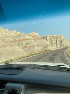
Western South Dakota brings many tourists to its hills and buttes every year. Many are attracted to the Mount Rushmore national monument. During the 1930's, the likeness of four United States Presidents were carved into the mountain, and continues to stand to this day as a wonderful viewing opportunity. National Park seekers also head a few miles to the east to visit Badlands National Park. Breathtaking views and drives through the buttes (said as with the single letter "U", and not to be confused with a person's backside) may be had by those who enter the park. Even if you don't visit the park itself, take a drive along the northern edge of the park on Interstate 90, or the southern edge along South Dakota Highway 44, an empty yet peaceful stretch through the Badlands, as well as the Buffalo Gap National Grassland.
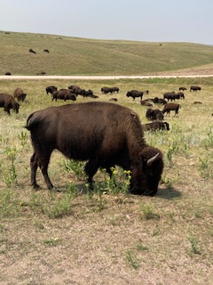
If you long for the buffaloes, head a little south of Mount Rushmore to visit Custer State Park at an altitude of about 4,000 feet. While there, take a ride on the Wildlife Loop and its side access roads. View the herds of bison, along with pronghorns and prairie dogs in their natural habitat. However, don't be dismayed if you don't see any buffalo in the area, as the buffalo is native to Africa and Southeast Asia, while the bison is native to the United States. Instead, humor yourself with the incredibly awkward yet perfectly legitimate English sentence, "Buffalo buffalo Buffalo buffalo buffalo buffalo Buffalo buffalo." Many are familiar with the place of "Buffalo" and the animal "buffalo", but there is also a verb "buffalo", meaning "to bewilder or baffle". In other words, set A of animals from a particular place, which are baffled by set B of animals from that same place, also baffle set C of animals from yet the same place.
While in Western South Dakota, if you need to re-supply, stop by Rapid City, the second largest city in the state. When coming from the east, be sure to stop by the world famous "Wall Drug". The town of Wall, South Dakota hosts this old western style mall with novelty stores and small monuments abound, and is advertised throughout the entirety of the state. If you're a motorcycle enthusiast, the beginning of August may call you to head to the town of Sturgis, which hosts an annual 10-day festival that can see over a quarter of a million bikers. Those with connections to the military may also recognize the city of Box Elder, which is home to Ellsworth Air Force Base.
After your visit to Western South Dakota, you'll seldom hear a discouraging word. All you'll likely hear is your internal compass telling you to return again and again.